Summary of How to interface GPS with AVR microcontroller (ATmega16)
This article explains interfacing a GPS modem with the ATmega16 microcontroller to extract and display location coordinates (latitude and longitude) from the GPGGA NMEA string on an LCD. The GPS modem outputs serial RS232 signals, which are converted using a MAX232 level converter before connecting to the microcontroller. The article details the pin connections for the serial interface and describes the GPS string format, highlighting key data such as time, latitude, longitude, number of satellites, and altitude.
Parts used in the GPS Interfacing with ATmega16 Project:
- GPS modem
- ATmega16 microcontroller
- MAX232 level converter
- LCD display
- Serial cross cable connections (wiring)
GPS modem is a device which receives signals from satellite and provides information about latitude, longitude, altitude, time etc. The GPS navigator is more famous in mobiles to track the road maps. The GPS modem has an antenna which receives the satellite signals and transfers them to the modem. The modem in turn converts the data into useful information and sends the output in serial RS232 logic level format. The information about latitude, longitude etc is sent continuously and accompanied by an identifier string.
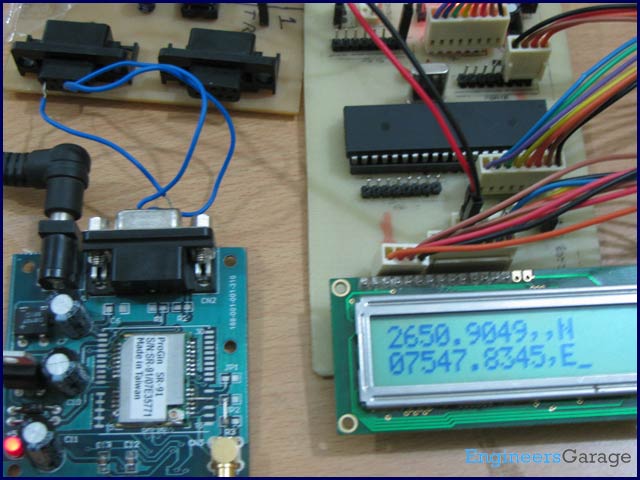
This article shows how to interface the GPS modem with ATmega16 and extract the location (latitude and longitude) from the GPGGA string and display it on LCD.
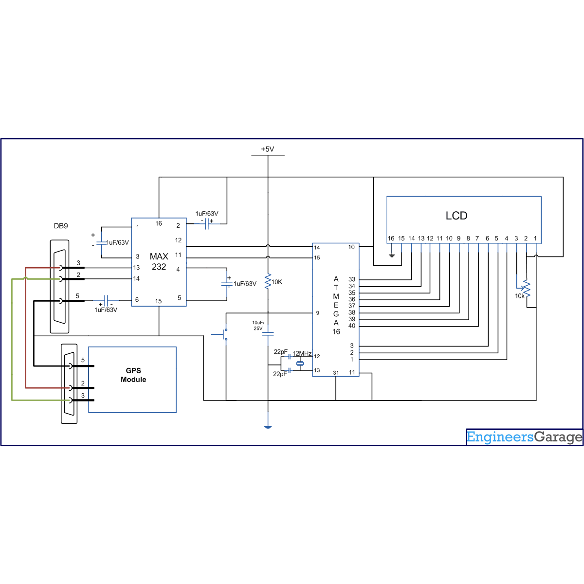
The connection of GPS modem with AVR microcontroller (ATmega 16) is shown in the circuit diagram. The ground pin of max 232 and serial o/p of GPS modem is made common. Pin2 of MAX232 is connected to pin 3 of GPS modem and pin 3 of max 232 is connected to pin 2 of modem. This type of connection is called a serial cross cable.
Pin 2 of MAX232 | Pin 3 of GPS Modem |
Pin 3 of MAX232 | Pin 2 of GPS Modem |
Pin 5 Ground Pin of MAX232 | Pin 5 Ground of GPS Modem |
The commonly available GPS modem gives output in serial (RS232) form. The output consists of a series of string.
String format:
The following is an example of the output string from the GPS module with its explanation. This output strings contains information about latitude, longitude, time etc and will always start with $GPGGA. Refer NMEA Standards for more details on string formats.
An example string has been given and explained below:
$GPGGA,100156.000,2650.9416,N,07547.8441,E,1,08,1.0,442.8,M,-42.5,M,,0000*71
1. A string always start from ‘$’ sign
2. GPGGA :Global Positioning System Fix Data
3. ‘,’ Comma indicates the separation between two values
4. 100156.000 : GMT time as 10(hr):01(min):56(sec):000(ms)
5. 2650.9416,N: Latitude 26(degree) 50(minutes) 9416(sec) NORTH
6. 07547.8441,E: Longitude 075(degree) 47(minutes) 8441(sec) EAST
7. 1 : Fix Quantity 0= invalid data, 1= valid data, 2=DGPS fix
8. 08 : Number of satellites currently viewed.
9. 1.0: HDOP
10. 442.8,M : Altitude (Height above sea level in meter)
11. -42.5,M : Geoids height
12. __ , DGPS data
13. 0000 : DGPS data
14. *71 : checksum
For more detail: How to interface GPS with AVR microcontroller (ATmega16)