
Summary of Latitude & Longitude Display System Using GPS & AVR Microcontroller
This article explains a project for interfacing a GPS receiver with an AVR microcontroller to display latitude and longitude. It details how the Global Positioning System uses satellites to transmit data, allowing a receiver to calculate its location by connecting to at least three satellites simultaneously. The system processes string-formatted information like altitude and time to determine precise positioning on Earth.
Parts used in the Longitude and Latitude Display System:
- GPS Receiver
- AVR Microcontroller
- Satellites (Minimum of 3 required)
This project is a reference to budding engineers or a helping hand to those who willing to work and interface a GPS Receiver with microcontrollerand making their own channel to communicate with satellite, seeking for some useful information from satellite to make a effective and efficient system.
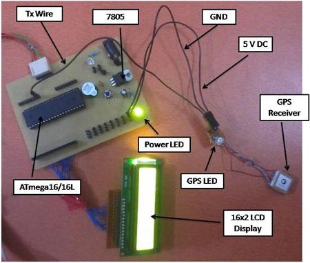
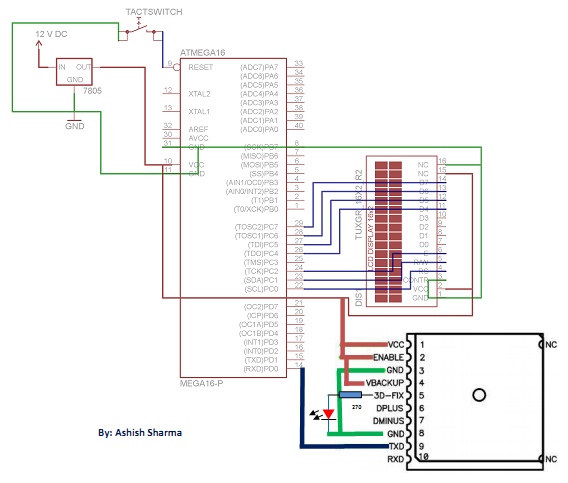
Before we check all the details of this project, here is the final implemented circuit diagram of longitude and latitude display system using GPS and AVR microcontroller.
GPS
In a simplest way ‘The Global Positioning System (GPS)’ is a satellite-based navigation system that consists of 24 orbiting satellites. This satellite transmits an amount of information in string format (e.g.: latitude, longitude, altitude, time etc.) which we are going to cover further.
GPS Receiver
GPS Receiver received the information in string format, transmitted by Satellites, which uses this information to calculate different parameters between it and satellites. With information from satellites, a GPS receiver can fix its location on the ground from the known position of the satellites.
Now I want to drag your attention on the purpose of this project. In this project, we are going to display ‘Latitude & Longitude’ used for positioning of an object on the earth. So let’s talk about how a GPS receiver fixes its location on the ground, as i above said and the find the location of an object on the earth.
Position Locator
Let me tell you, if we want an object location on the earth, GPS receiver have to connect with minimum 3 Satellite at the point of time. Now i explain this in a simple way by the help of fig 1.1:
In Fig 1.1, I am trying to symbolize ‘Earth with a Sky Blue Circle’, ‘Satellites with Dark Blue’, ‘Satellites radius with Black outline circle’ and the ‘position with small Red circle’.
So let us assume we are standing on the earth with GPS Receiver and receiver is connected with two satellites- Satellite 1 and Satellite 2 at the time of instant. Both satellites have its own radius and after connecting with GPS Receiver, both radius will intersect with two points. This means we got two positions of us with respect to satellite at the same point of time which is practically not possible. So we will not able to fix our fix position in this case.
Problem solved. If our GPS receiver is connect with minimum 3 satellite at point of time, we got three radius by Satellite 1, Satellite 2 and Satellite 3, and all three radius will intersect in a common point and that common intersect point is our fix location on the earth with respect to satellites, that I meant in the starting of this section. I hope now you will be able to understand the concept.
For more detail: Latitude & Longitude Display System Using GPS & AVR Microcontroller
-
What is the purpose of this project?
The project aims to display latitude and longitude for positioning an object on Earth by interfacing a GPS receiver with a microcontroller. -
How many satellites does a GPS receiver need to connect with?
A GPS receiver must connect with a minimum of three satellites at one point in time to fix its location. -
What kind of information do satellites transmit?
Satellites transmit information in string format such as latitude, longitude, altitude, and time. -
Why is connecting to only two satellites insufficient?
Connecting to two satellites results in two intersection points, making it impossible to fix a single specific position. -
What happens when three satellite radii intersect?
When the radii from three satellites intersect at a common point, that point represents the fixed location on Earth. -
Which microcontroller is used in this implementation?
The project utilizes an AVR microcontroller to process the data from the GPS receiver. -
How does the GPS receiver calculate parameters?
The receiver calculates different parameters between itself and the satellites using the received string information.
